 Tweet
Tweet
Just wondering if someone could advise how to enter co ordinates correctly into the following grids? I must admit I struggle a bit with the varying formats and can never remember which is which, and the NW/SE bit has me completely confused. I'm sure I suffer from dyscalcula. 
No matter which combination I try it comes back with what I assume is an error message.
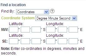
The grids above are off the Landgate website. For those that arent aware, their images of WA are generally far superior to Google Earth and Nearmaps (outside of metro areas).
http://www.landgate.wa.gov.au/corpor...web/index.html
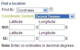
No matter which combination I try it comes back with what I assume is an error message.
The grids above are off the Landgate website. For those that arent aware, their images of WA are generally far superior to Google Earth and Nearmaps (outside of metro areas).
http://www.landgate.wa.gov.au/corpor...web/index.html
Comment